
Thank you for supporting this site ❤️
Make a donation
Make a donation
Temuka topographic map
Click on the map to display elevation.
Thank you for supporting this site ❤️
Make a donation
Make a donation
About this map
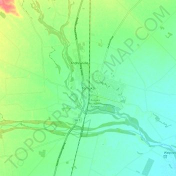
Name: Temuka topographic map, elevation, terrain.
Location: Temuka, Timaru District, Canterbury, 7920, New Zealand (-44.28396 171.23973 -44.20396 171.31973)
Average elevation: 24 m
Minimum elevation: 2 m
Maximum elevation: 75 m
Thank you for supporting this site ❤️
Make a donation
Make a donation
Other topographic maps
Click on a map to view its topography, its elevation and its terrain.