
Make a donation
Lancaster County topographic map
Click on the map to display elevation.
Make a donation
About this map
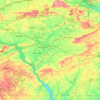
Name: Lancaster County topographic map, elevation, terrain.
Location: Lancaster County, Pennsylvania, United States (39.72110 -76.72196 40.31571 -75.87329)
Average elevation: 158 m
Minimum elevation: 28 m
Maximum elevation: 412 m
Make a donation
Other topographic maps
Click on a map to view its topography, its elevation and its terrain.
Culmerville
United States > Pennsylvania > Allegheny County > West Deer Township
Average elevation: 341 m
Make a donation
Gladwyne
United States > Pennsylvania > Montgomery County > Lower Merion Township
Average elevation: 92 m
Make a donation
Water Street
United States > Pennsylvania > Huntingdon County > Morris Township
Average elevation: 319 m
Coverdale
United States > Pennsylvania > Allegheny County > Bethel Park > Coverdale
Average elevation: 354 m
Make a donation
Philadelphia
United States > Pennsylvania > Philadelphia County > Philadelphia
Average elevation: 35 m
Five Points
United States > Pennsylvania > Westmoreland County > Salem Township > Five Points
Average elevation: 385 m