
Make a donation
Philadelphia topographic map
Click on the map to display elevation.
Make a donation
About this map
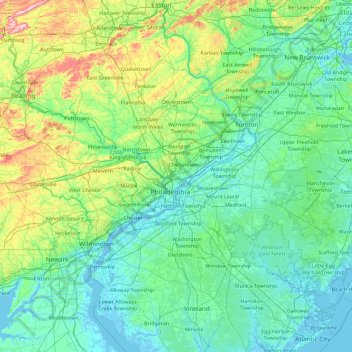
Name: Philadelphia topographic map, elevation, terrain.
Location: Philadelphia, Pennsylvania, 19140, United States (39.31145 -75.83265 40.71145 -74.43265)
Average elevation: 68 m
Minimum elevation: -4 m
Maximum elevation: 496 m
Make a donation
Other topographic maps
Click on a map to view its topography, its elevation and its terrain.
State College
United States > Pennsylvania > Centre County
State College is located at an elevation of approximately 1,200 feet (370 m) above sea level. According to the U.S. Census Bureau, the borough has a total area of 4.5 square miles (12 km2), all land. It is surrounded by large tracts of farmland and an expanse of Appalachian Mountain ranges and forests. Its…
Average elevation: 351 m
Make a donation
Wilkes-Barre
United States > Pennsylvania > Luzerne County
According to the U.S. Census Bureau, the city has a total area of 7.2 square miles (19 km2), of which 6.8 square miles (18 km2) is land and 0.3 square miles (0.78 km2), or 4.60%, is water. The city is bordered by the Susquehanna River to the west. Most of Downtown is located on a wide floodplain. Floodwalls…
Average elevation: 218 m
Make a donation
Make a donation
Make a donation
Hamilton Township
United States > Pennsylvania > Franklin County > Hamilton Township
Average elevation: 213 m
Make a donation