
Thank you for supporting this site ❤️
Make a donation
Make a donation
Yopurga County topographic map
Click on the map to display elevation.
Thank you for supporting this site ❤️
Make a donation
Make a donation
About this map
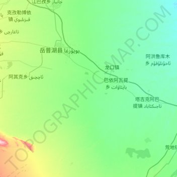
Name: Yopurga County topographic map, elevation, terrain.
Location: Yopurga County, Kachgar, Xinjiang, China (38.80540 76.40739 39.32227 77.40725)
Average elevation: 1,203 m
Minimum elevation: 1,161 m
Maximum elevation: 1,467 m
Thank you for supporting this site ❤️
Make a donation
Make a donation
Other topographic maps
Click on a map to view its topography, its elevation and its terrain.
Thank you for supporting this site ❤️
Make a donation
Make a donation
Thank you for supporting this site ❤️
Make a donation
Make a donation
Thank you for supporting this site ❤️
Make a donation
Make a donation
Tian Shan
China > Xinjiang > Wensu County
Continuous permafrost is typically found in the Tian Shan starting at the elevation of about 3,500-3,700 m above the sea level. Discontinuous alpine permafrost usually occurs down to 2,700-3,300 m, but in certain locations, due to the peculiarity of the aspect and the microclimate, it can be found at…
Average elevation: 6,096 m