
Buffalo topographic map
Interactive map
Click on the map to display elevation.
About this map
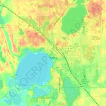
Name: Buffalo topographic map, elevation, terrain.
Location: Buffalo, Wright County, Minnesota, 55313, United States (45.13790 -93.91014 45.21229 -93.82690)
Average elevation: 297 m
Minimum elevation: 273 m
Maximum elevation: 322 m
Other topographic maps
Click on a map to view its topography, its elevation and its terrain.
Rockford
United States > Minnesota > Wright County
Rockford, Wright County, Minnesota, United States
Average elevation: 296 m
Delano
United States > Minnesota > Wright County
Delano, Wright County, Minnesota, 55328, United States
Average elevation: 289 m
Otsego
United States > Minnesota > Wright County
Otsego, Wright County, Minnesota, United States
Average elevation: 281 m
Monticello Township
United States > Minnesota > Wright County
Monticello Township, Wright County, Minnesota, United States
Average elevation: 297 m
Albertville
United States > Minnesota > Wright County
Albertville, Wright County, Minnesota, 55301, United States
Average elevation: 292 m
Hanover
United States > Minnesota > Wright County
Hanover, Wright County, Minnesota, 55341, United States
Average elevation: 291 m
Montrose
United States > Minnesota > Wright County
Montrose, Wright County, Minnesota, United States
Average elevation: 294 m
Howard Lake
United States > Minnesota > Wright County
Howard Lake, Wright County, Minnesota, 55349, United States
Average elevation: 312 m
Silver Creek Township
United States > Minnesota > Wright County
Silver Creek Township, Wright County, Minnesota, 55380, United States
Average elevation: 303 m
Albion Center
United States > Minnesota > Wright County
Albion Center, Albion Township, Wright County, Minnesota, United States
Average elevation: 320 m
St. Michael
United States > Minnesota > Wright County
St. Michael, Wright County, Minnesota, 55376, United States
Average elevation: 290 m
Monticello
United States > Minnesota > Wright County
Monticello, Wright County, Minnesota, 55362, United States
Average elevation: 289 m
Maple Lake Township
United States > Minnesota > Wright County
Maple Lake Township, Wright County, Minnesota, 55358, United States
Average elevation: 310 m
South Haven
United States > Minnesota > Wright County
South Haven, Wright County, Minnesota, United States
Average elevation: 333 m
Maple Lake
United States > Minnesota > Wright County > Maple Lake > Maple Lake
Maple Lake, Wright County, Minnesota, 55358, United States
Average elevation: 314 m
South Haven
United States > Minnesota > Wright County > South Haven > South Haven
South Haven, Wright County, Minnesota, 55382, United States
Average elevation: 331 m
Rockford
United States > Minnesota > Wright County > Rockford > Rockford
Rockford, Wright County, Minnesota, 55313:55373, United States
Average elevation: 298 m
Annandale
United States > Minnesota > Wright County > Annandale > Annandale
Annandale, Wright County, Minnesota, 55302, United States
Average elevation: 324 m
Annandale
United States > Minnesota > Wright County
Annandale, Wright County, Minnesota, 55302, United States
Average elevation: 323 m
Maple Lake
United States > Minnesota > Wright County
Maple Lake, Wright County, Minnesota, United States
Average elevation: 314 m