
Palestinian Territories topographic map
Interactive map
Click on the map to display elevation.
About this map
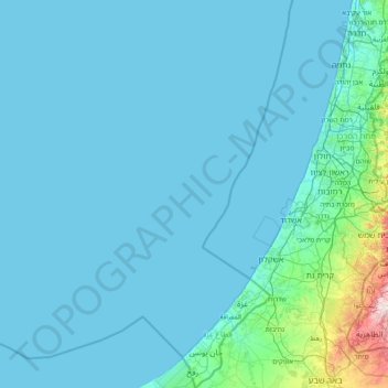
Name: Palestinian Territories topographic map, elevation, terrain.
Location: Palestinian Territories (31.22013 34.05469 32.54894 35.54036)
Average elevation: 44 m
Minimum elevation: 0 m
Maximum elevation: 896 m
Other topographic maps
Click on a map to view its topography, its elevation and its terrain.
Efrat
Palestinian Territories > Judea and Samaria > Area C
Efrat, Area C, Judea and Samaria, Palestinian Territories
Average elevation: 898 m
Kiryat Arba
Palestinian Territories > Judea and Samaria > Area C
Kiryat Arba, Area C, Judea and Samaria, Palestinian Territories
Average elevation: 917 m
Ariel
Palestinian Territories > Judea and Samaria > Area C > Ariel
Ariel, Area C, Judea and Samaria, 4075419, Palestinian Territories
Average elevation: 506 m
Efrat
Palestinian Territories > Judea and Samaria > Area C > Efrat > Efrat
Efrat, Area C, Judea and Samaria, 9045634, Palestinian Territories
Average elevation: 855 m