
Rhode Island topographic map
Interactive map
Click on the map to display elevation.
About this map
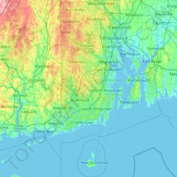
Name: Rhode Island topographic map, elevation, terrain.
Location: Rhode Island, United States (41.09583 -71.90743 42.01894 -71.08857)
Average elevation: 53 m
Minimum elevation: -8 m
Maximum elevation: 393 m
Rhode Island covers an area of 1,214 square miles (3,144 km2) within the New England region of the Northeastern United States and is bordered on the north and east by Massachusetts, on the west by Connecticut, and on the south by Rhode Island Sound and the Atlantic Ocean. It shares a narrow maritime border with New York State between Block Island and Long Island. The state's mean elevation is 200 feet (61 m). It is only 37 miles (60 km) wide and 48 miles (77 km) long, yet the state has a tidal shoreline on Narragansett Bay and the Atlantic Ocean of 384 miles (618 km).
Other topographic maps
Click on a map to view its topography, its elevation and its terrain.
Los Angeles
Los Angeles, Los Angeles County, California, United States
Average elevation: 241 m
Brooklyn
United States > New York > New York
Brooklyn, Kings County, New York, United States
Average elevation: 9 m
Houston
United States > Texas > Harris County
Houston, Harris County, Texas, United States
Average elevation: 25 m
Santa Barbara
United States > California > Santa Barbara County
Santa Barbara, Santa Barbara County, California, United States
Average elevation: 119 m
Tampa
United States > Florida > Hillsborough County
Tampa, Hillsborough County, Florida, United States
Average elevation: 11 m
Cochise County
Cochise County, Arizona, United States
Average elevation: 1,410 m
Appalachian Mountains
United States > North Carolina > Yancey County
Appalachian Mountains, Yancey County, North Carolina, United States
Average elevation: 1,463 m
New Orleans
United States > Louisiana > Orleans Parish
New Orleans, Orleans Parish, Louisiana, United States
Average elevation: 1 m
Somerville
United States > Massachusetts > Middlesex County
Somerville, Middlesex County, Massachusetts, United States
Average elevation: 11 m
Sarasota
United States > Florida > Sarasota County
Sarasota, Sarasota County, Florida, United States
Average elevation: 7 m
Honolulu
United States > Hawaii > Honolulu County
Honolulu, Honolulu County, Hawaii, United States
Average elevation: 90 m
Santa Cruz
United States > California > Santa Cruz County
Santa Cruz, Santa Cruz County, California, United States
Average elevation: 89 m
Knoxville
United States > Tennessee > Knox County
Knoxville, Knox County, East Tennessee, Tennessee, United States
Average elevation: 307 m
Jacksonville
United States > Florida > Duval County
Jacksonville, Duval County, Florida, United States
Average elevation: 10 m
Lancaster County
Lancaster County, Pennsylvania, United States
Average elevation: 158 m
Allegheny County
Allegheny County, Pennsylvania, United States
Average elevation: 325 m
Queens County
United States > New York > New York
Queens County, New York, United States
Average elevation: 11 m