
Odisha topographic map
Click on the map to display elevation.
Odisha
Three-quarters of the state is covered in mountain ranges. Deep and broad valleys have been made in them by rivers. These valleys have fertile soil and are densely populated. Odisha also has plateaus and rolling uplands, which have lower elevation than the plateaus.[57] The highest point in the state is Deomali at 1,672 metres in Koraput district. Some other high peaks are: Sinkaram (1,620 m), Golikoda (1,617 m), and Yendrika (1,582 metres).[60]
About this map
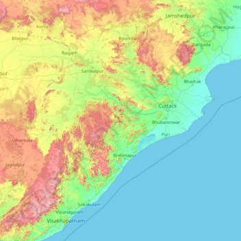
Name: Odisha topographic map, elevation, terrain.
Location: Odisha, India (17.79490 81.38859 22.56765 87.48580)
Average elevation: 227 m
Minimum elevation: -1 m
Maximum elevation: 1,584 m
Other topographic maps
Click on a map to view its topography, its elevation and its terrain.
Bhubaneshwar
India > Odisha > Bhubaneswar (M.Corp.)
Bhubaneswar is in Khordha district of Odisha. It is in the eastern coastal plains, along the axis of the Eastern Ghats mountains. The city has an average altitude of 45 m (148 ft) above sea level. Bhubaneswar lies in Mahanadi River Delta. The Daya River is 4 km to the south and the Kuakhai River 4 km to the…
Average elevation: 30 m
Magadi
India > Karnataka > Magadi taluku
Magadi is located at 12°58′N 77°14′E / 12.97°N 77.23°E / 12.97; 77.23. It has an average elevation of 925 metres (3034 feet).
Average elevation: 872 m
Bikaner
India > Rajasthan > Bikaner Tehsil
Around a century after Rao Bika founded Bikaner, the state's fortunes flourished under the sixth Raja, Rai Singhji, who ruled from 1571 to 1611. During the Mughal Empire's rule in the country, Raja Rai Singh accepted the suzerainty of the Mughals and held a high rank as an army general at the court of the…
Average elevation: 225 m