
Wales topographic map
Interactive map
Click on the map to display elevation.
About this map
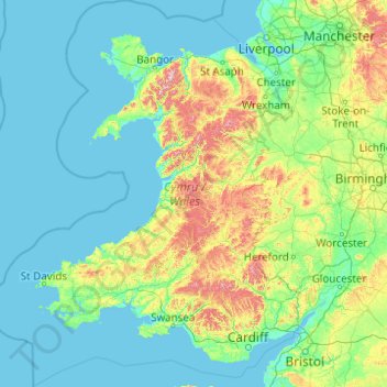
Name: Wales topographic map, elevation, terrain.
Location: Wales, United Kingdom (51.22903 -5.80773 53.63500 -2.64986)
Average elevation: 99 m
Minimum elevation: 0 m
Maximum elevation: 1,001 m
Much of Wales' diverse landscape is mountainous, particularly in the north and central regions. The mountains were shaped during the last ice age, the Devensian glaciation. The highest mountains in Wales are in Snowdonia (Eryri), of which five are over 1,000 m (3,300 ft). The highest of these is Snowdon (Yr Wyddfa), at 1,085 m (3,560 ft). The 14 Welsh mountains, or 15 if including Carnedd Gwenllian – often discounted because of its low topographic prominence – over 3,000 feet (910 metres) high are known collectively as the Welsh 3000s and are located in a small area in the north-west. The highest outside the 3000s is Aran Fawddwy, at 905 metres (2,969 feet), in the south of Snowdonia. The Brecon Beacons (Bannau Brycheiniog) are in the south (highest point Pen y Fan, at 886 metres (2,907 feet)), and are joined by the Cambrian Mountains in Mid Wales (highest point Pumlumon, at 752 metres (2,467 feet)).
Other topographic maps
Click on a map to view its topography, its elevation and its terrain.
London
United Kingdom > England > London
London, Greater London, England, SW1A 2DX, United Kingdom
Average elevation: 42 m
London
London, Greater London, England, United Kingdom
Average elevation: 66 m
Bristol
United Kingdom > England > City of Bristol
Bristol, City of Bristol, West of England, England, United Kingdom
Average elevation: 55 m
The Cotswolds National Landscape
United Kingdom > England > Gloucestershire
The Cotswolds National Landscape, Gloucestershire, West of England, England, United Kingdom
Average elevation: 109 m
Edinburgh
United Kingdom > Scotland > Edinburgh
Edinburgh, City of Edinburgh, Scotland, EH1 3EG, United Kingdom
Average elevation: 104 m
Greater Manchester
Greater Manchester, England, United Kingdom
Average elevation: 141 m
Cardiff
United Kingdom > Wales > Cardiff
Cardiff, Wales, CF10 2AF, United Kingdom
Average elevation: 55 m
Cambrian Mountains
United Kingdom > Wales > Powys
Cambrian Mountains, Powys, Wales, SY18 6JR, United Kingdom
Average elevation: 319 m
West Midlands
United Kingdom > England > Warwickshire
West Midlands, Warwickshire, West Midlands Combined Authority, England, United Kingdom
Average elevation: 113 m
Belfast
United Kingdom > Northern Ireland > County Antrim
Belfast, County Antrim, Northern Ireland, BT1 5GS, United Kingdom
Average elevation: 87 m
Lake District National Park
Lake District National Park, England, United Kingdom
Average elevation: 206 m
Liverpool
Liverpool, Liverpool City Region, England, United Kingdom
Average elevation: 26 m
Gloucestershire
Gloucestershire, England, United Kingdom
Average elevation: 99 m
Lancashire
Lancashire, North West England, England, United Kingdom
Average elevation: 153 m
Lincoln
United Kingdom > England > Lincolnshire
Lincoln, Lincolnshire, England, United Kingdom
Average elevation: 29 m
Hull
United Kingdom > England > Kingston upon Hull
Hull, Kingston upon Hull, England, HU1 3RJ, United Kingdom
Average elevation: 21 m
Durham
United Kingdom > England > County Durham
Durham, County Durham, North East, England, DH1 3NG, United Kingdom
Average elevation: 119 m
Aviemore
United Kingdom > Scotland > Highland
Aviemore, Highland, Scotland, PH22 1RN, United Kingdom
Average elevation: 331 m
Bath
United Kingdom > England > Bath and North East Somerset
Bath, Bath and North East Somerset, West of England, England, United Kingdom
Average elevation: 100 m
Newcastle upon Tyne
Newcastle upon Tyne, North of Tyne, England, United Kingdom
Average elevation: 57 m
Sheffield
Sheffield, South Yorkshire, England, United Kingdom
Average elevation: 168 m
North Yorkshire
North Yorkshire, Yorkshire and the Humber, England, United Kingdom
Average elevation: 153 m
Canterbury
United Kingdom > England > Kent
Canterbury, Kent, England, United Kingdom
Average elevation: 51 m
Birmingham
Birmingham, West Midlands Combined Authority, England, United Kingdom
Average elevation: 138 m
Glasgow
United Kingdom > Scotland > Glasgow City
Glasgow, Glasgow City, Scotland, G2 1DY, United Kingdom
Average elevation: 128 m
South East England
South East England, England, United Kingdom
Average elevation: 69 m
City of London
United Kingdom > England > City of London > City of London
City of London, England, EC2V 5AE, United Kingdom
Average elevation: 42 m
Greater London
Greater London, England, United Kingdom
Average elevation: 66 m
Norwich
United Kingdom > England > Norfolk
Norwich, Norfolk, England, United Kingdom
Average elevation: 28 m
Leicester
United Kingdom > England > Leicestershire
Leicester, Leicestershire, England, LE1 5YA, United Kingdom
Average elevation: 109 m
Brighton
United Kingdom > England > Brighton and Hove
Brighton, Brighton and Hove, England, United Kingdom
Average elevation: 64 m
Buxton
United Kingdom > England > Derbyshire > High Peak
Buxton, High Peak, Derbyshire, England, United Kingdom
Average elevation: 334 m
Shropshire
Shropshire, West Midlands, England, United Kingdom
Average elevation: 166 m
City of Edinburgh
City of Edinburgh, Scotland, United Kingdom
Average elevation: 118 m
Wirral
Wirral, Liverpool City Region, England, United Kingdom
Average elevation: 21 m
Corby
United Kingdom > England > North Northamptonshire > Corby
Corby, North Northamptonshire, East Midlands, England, United Kingdom
Average elevation: 98 m
Nottingham
United Kingdom > England > Nottinghamshire
Nottingham, England, United Kingdom
Average elevation: 56 m
Leeds
United Kingdom > England > Leeds
Leeds, Yorkshire and the Humber, England, LS1 6AL, United Kingdom
Average elevation: 94 m