
Thank you for supporting this site ❤️
Make a donation
Make a donation
Simon Pond topographic map
Click on the map to display elevation.
Thank you for supporting this site ❤️
Make a donation
Make a donation
About this map
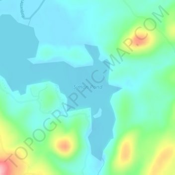
Name: Simon Pond topographic map, elevation, terrain.
Location: Simon Pond, Franklin County, New York, United States (44.18029 -74.47213 44.20520 -74.43076)
Average elevation: 502 m
Minimum elevation: 466 m
Maximum elevation: 638 m
Thank you for supporting this site ❤️
Make a donation
Make a donation
Other topographic maps
Click on a map to view its topography, its elevation and its terrain.
Thank you for supporting this site ❤️
Make a donation
Make a donation
Thank you for supporting this site ❤️
Make a donation
Make a donation
Upper Saint Regis
United States > New York > Franklin County > Town of Harrietstown
Average elevation: 509 m
Thank you for supporting this site ❤️
Make a donation
Make a donation
Lower Chateaugay Lake
United States > New York > Franklin County > Town of Ellenburg
Average elevation: 487 m
Thank you for supporting this site ❤️
Make a donation
Make a donation
Westville Center
United States > New York > Franklin County > Westville Center
Average elevation: 75 m
Thank you for supporting this site ❤️
Make a donation
Make a donation