
Make a donation
Forestdale topographic map
Click on the map to display elevation.
Make a donation
About this map
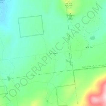
Name: Forestdale topographic map, elevation, terrain.
Average elevation: 516 m
Minimum elevation: 427 m
Maximum elevation: 740 m
Make a donation
Other topographic maps
Click on a map to view its topography, its elevation and its terrain.
Upper Saint Regis Lake
United States > New York > Franklin County > Town of Harrietstown
Average elevation: 506 m
Make a donation
Make a donation
Mountain View Lake
United States > New York > Franklin County > Mountain View
Average elevation: 472 m
Fish Creek Pond Campground
United States > New York > Franklin County > Santa Clara
Average elevation: 488 m
Make a donation
Lower Chateaugay Lake
United States > New York > Franklin County > Town of Ellenburg
Average elevation: 487 m
Meacham Lake
United States > New York > Franklin County
Meacham Lake is a 1,203-acre (4.87 km2) lake eight miles north of Paul Smiths in Franklin County, New York in the Adirondack Park. It is 2 miles (3.2 km) long, north to south, and 1 mile (1.6 km) wide. The lake is found at an elevation of 1,552 feet (473 m). Most of the lake is in the town of Duane; the…
Average elevation: 489 m
Make a donation
Make a donation