
Make a donation
Meacham Lake topographic map
Click on the map to display elevation.
Make a donation
Meacham Lake
Meacham Lake is a 1,203-acre (4.87 km2) lake eight miles north of Paul Smiths in Franklin County, New York in the Adirondack Park. It is 2 miles (3.2 km) long, north to south, and 1 mile (1.6 km) wide. The lake is found at an elevation of 1,552 feet (473 m). Most of the lake is in the town of Duane; the southernmost shore is in the town of Brighton.
Make a donation
About this map
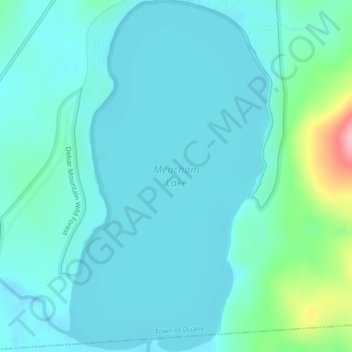
Name: Meacham Lake topographic map, elevation, terrain.
Average elevation: 489 m
Minimum elevation: 465 m
Maximum elevation: 618 m
Make a donation
Other topographic maps
Click on a map to view its topography, its elevation and its terrain.
Make a donation
Make a donation
Upper Saint Regis
United States > New York > Franklin County > Town of Harrietstown
Average elevation: 509 m
Make a donation
Lower Chateaugay Lake
United States > New York > Franklin County > Town of Ellenburg
Average elevation: 487 m
Make a donation
Westville Center
United States > New York > Franklin County > Westville Center
Average elevation: 75 m
Make a donation