
South Carolina topographic map
Interactive map
Click on the map to display elevation.
South Carolina
South Carolina's topography is defined by three major geographic regions: the Atlantic Coastal Plain, the Piedmont, and the Blue Ridge Mountains. Covering approximately two-thirds of the state, the Atlantic Coastal Plain is characterized by flat, gently rolling terrain that transitions from the sandy beaches along the Atlantic Ocean to swamps and estuaries further inland. The coastal areas are interspersed with barrier islands and unique features like Carolina bays—elliptical depressions formed by various geological processes. Moving inland, the Piedmont region features rolling hills and elevated plateaus, with elevations generally ranging from 400 to 1,200 feet (122 to 366 meters), and includes the distinctive fall line where the rivers descend to the lower coastal plain. The northwest corner of the state rises into the Blue Ridge Mountains, with Sassafras Mountain as the highest point at 3,560 feet (1,085 meters). This area is known for its rugged terrain, steep slopes, and rich biodiversity. Overall, South Carolina's diverse topography reflects a rich geological history influenced by ancient mountains, river systems, and coastal dynamics.
About this map
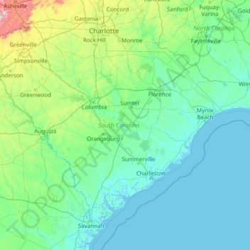
Name: South Carolina topographic map, elevation, terrain.
Location: South Carolina, United States (32.03345 -83.35400 35.21549 -78.54135)
Average elevation: 85 m
Minimum elevation: -4 m
Maximum elevation: 1,642 m
Other topographic maps
Click on a map to view its topography, its elevation and its terrain.
Cobb
United States > California > Lake County
Cobb is a census designated place (CDP) in Lake County, California, United States. Cobb is located 1 mile (1.6 km) northwest of Whispering Pines, at an elevation of 2,631 feet (802 m). The population was 1,778 at the 2010 census, up from 1,638 at the 2000 census.
Average elevation: 887 m
Mercury
United States > Nevada > Nye County
In 1957, the US Navy launched nine atmospheric sounding rockets to measure nuclear radiation and other atmospheric data, using Mercury as a staging area. The Naval Radiological Defense Laboratory conducted its first test flight in 1956. This test rocket lifted 13.6 kilograms (30 lb) to an altitude of 40…
Average elevation: 1,183 m
Mount Saint Helens
United States > Washington > Skamania County
The Mount St. Helens major eruption of May 18, 1980 remains the deadliest and most economically destructive volcanic event in U.S. history. Fifty-seven people were killed; 200 homes, 47 bridges, 15 miles (24 km) of railways, and 185 miles (298 km) of highway were destroyed. A massive debris avalanche,…
Average elevation: 2,096 m
Miami
United States > Florida > Miami-Dade County > Miami
Miami and its suburbs are located on a broad plain between the Everglades to the west and Biscayne Bay to the east, which extends from Lake Okeechobee southward to Florida Bay. The elevation of the area averages at around 6 ft (1.8 m) above sea level in most neighborhoods, especially near the coast. The…
Average elevation: 4 m
Atlanta
United States > Georgia > Fulton County > Atlanta
Atlanta (/ætˈlæntə/ at-LAN-tə) is the capital and most populous city of the U.S. state of Georgia. It lies primarily within Fulton County (for which it serves as county seat) with about 10% of the city lying within neighboring DeKalb County. With a population of 498,715 living within the city limits, it…
Average elevation: 285 m
Sullvan Town Park
United States > New York > Madison County > Town of Sullivan > Village of Chittenango
Average elevation: 161 m
Bombay Beach
The derelict "living ghost town" status of Bombay Beach has attracted many photographers, filmmakers, urban explorers, and tourists, to the point that locals tend to ask visitors if they are filmmakers that are there to shoot a documentary. The town, as well as others on the shores of the Salton Sea, is one of…
Average elevation: -61 m
Lovely
United States > Pennsylvania > Bedford County > Lincoln Township > Lovely
Average elevation: 476 m