
Make a donation
Shortoff Mountain topographic map
Click on the map to display elevation.
Make a donation
About this map
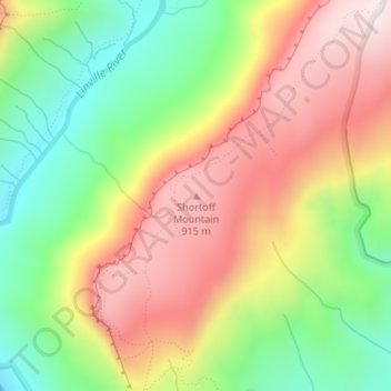
Name: Shortoff Mountain topographic map, elevation, terrain.
Average elevation: 672 m
Minimum elevation: 405 m
Maximum elevation: 948 m
Make a donation
Other topographic maps
Click on a map to view its topography, its elevation and its terrain.
Pisgah National Forest
United States > North Carolina > Buncombe County
The Pisgah National Forest covers 512,758 acres (801 sq mi; 2,075 km2) of mountainous terrain in the southern Appalachian Mountains, including parts of the Blue Ridge Mountains and Great Balsam Mountains. Elevations reach over 6,000 feet (1,800 m) and include some of the highest mountains in the eastern United…
Average elevation: 752 m
Make a donation
Falls Lake
United States > North Carolina > Durham County
Work on the dam that holds the lake began in 1978 and was completed in 1981. Prior to its construction flooding of the Neuse River caused extensive damage to public and private properties including roadways, railroads, industrial sites and farmlands. The U.S. Army Corps of Engineers constructed and manages the…
Average elevation: 101 m
Make a donation
Make a donation
New River
United States > North Carolina > Alleghany County
On its journey through the New River Gorge, the New River passes through an extensive geological formation. Emergent rocks and rock outcrops are found to provide diverse habitat producing rich and abundant flora and fauna species. In the gorge, there is typically a 1000 feet difference in elevation between the…
Average elevation: 803 m
High Rock Lake
United States > North Carolina > Davidson County
At the time of construction, High Rock was the largest reservoir in North Carolina and one of the largest in the United States. When full, its surface covers 15,180 acres (61 km2) with 360 miles (579 km) of shoreline and is 59 feet (18 m) deep at the dam. Normal pool elevation is 624 feet above sea level…
Average elevation: 211 m
Make a donation
Make a donation
Make a donation
Murraysville
United States > North Carolina > New Hanover County > Murraysville
Average elevation: 12 m
Make a donation
Coulwood Park
United States > North Carolina > Mecklenburg County > Charlotte > Coulwood Hills
Average elevation: 211 m
Make a donation
Make a donation
Make a donation
Make a donation
Cajah's Mountain
United States > North Carolina > Caldwell County
Cajah's Mountain is located in southern Caldwell County. It is bordered to the north by Lenoir, the county seat. Cajah Mountain's highest elevation 1,530 feet (470 m), is at the southern end of the town next to Connelly Springs Road, the major north–south road through the town.
Average elevation: 390 m
Make a donation
Make a donation
Make a donation
Kitty Hawk
United States > North Carolina > Dare County
Kitty Hawk is located at 36°06′N 75°42′W / 36.1°N 75.7°W / 36.1; -75.7 at an elevation of 7 feet (2 m) above sea level.
Average elevation: 2 m
Make a donation
Mills River
United States > North Carolina > Henderson County > Mills River > Oak Hill Court
Average elevation: 633 m
Make a donation
Make a donation
Pharr Mill Park
United States > North Carolina > Cabarrus County > Pharrs Mill
Average elevation: 175 m
Make a donation
Make a donation
Make a donation
Idlewild Farms
United States > North Carolina > Mecklenburg County > Charlotte
Average elevation: 222 m
Make a donation
Grandfather Mountain State Park
United States > North Carolina > Watauga County > Banner Elk
Grandfather Mountain rises 5,964 feet (1,818 m) above sea level, and due to the considerable elevation gain the mountain boasts 16 distinct ecological communities. The mountain is famous for its rugged character, and is home to many hidden caves and significant cliffs.
Average elevation: 1,293 m
Make a donation
Royal Pines
United States > North Carolina > Buncombe County > Royal Pines
Royal Pines is bordered to the west by U.S. Route 25A and the city limits of Asheville, and to the northeast by Mills Gap Road. Brown Mountain, with an elevation of 2,996 feet (913 m), occupies the center of the CDP.
Average elevation: 714 m
Make a donation
Echo Lake
United States > North Carolina > Henderson County > Laurel Park > Country Ridge
Average elevation: 760 m
Make a donation
North Toe River
United States > North Carolina > Mitchell County > Spruce Pine
Average elevation: 824 m
Make a donation