
Thank you for supporting this site ❤️
Make a donation
Make a donation
Pine Mountain topographic map
Click on the map to display elevation.
Thank you for supporting this site ❤️
Make a donation
Make a donation
About this map
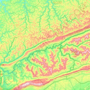
Name: Pine Mountain topographic map, elevation, terrain.
Location: Pine Mountain, Harlan County, Kentucky, 40988, United States (36.75770 -83.68539 36.95788 -83.13993)
Average elevation: 536 m
Minimum elevation: 267 m
Maximum elevation: 1,049 m
Thank you for supporting this site ❤️
Make a donation
Make a donation
Other topographic maps
Click on a map to view its topography, its elevation and its terrain.
Black Mountain
United States > Kentucky > Harlan County
Black Mountain is the highest mountain peak in the Commonwealth of Kentucky, United States, with a summit elevation of 4,145 feet (1,263 m) above mean sea level and a top-to-bottom height of over 2,500 feet (760 m). The summit is located at approximately 36°54′51″N 82°53′38″W / 36.91417°N…
Average elevation: 1,109 m
Thank you for supporting this site ❤️
Make a donation
Make a donation
Thank you for supporting this site ❤️
Make a donation
Make a donation