
Make a donation
The Vly topographic map
Click on the map to display elevation.
Make a donation
About this map
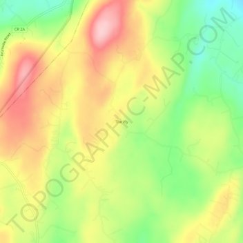
Name: The Vly topographic map, elevation, terrain.
Average elevation: 254 m
Minimum elevation: 160 m
Maximum elevation: 346 m
Make a donation
Other topographic maps
Click on a map to view its topography, its elevation and its terrain.
Slide Mountain Wilderness
United States > New York > Ulster County > Town of Shandaken > Town of Denning
Within its boundaries lie 10 of the 35 Catskill High Peaks, including the highest Catskill peak, Slide, 4,180 feet (1277 m) of elevation; and lowest, Rocky.
Average elevation: 584 m
Village of New Paltz
United States > New York > Ulster County > Town of New Paltz
Average elevation: 84 m
Saugerties South
United States > New York > Ulster County > Town of Saugerties
Average elevation: 33 m
Make a donation
Sojourner Truth State Park
United States > New York > Ulster County > City of Kingston > East Kingston
Average elevation: 38 m
Make a donation
Make a donation
Big Indian Park
United States > New York > Ulster County > Town of Shandaken > Big Indian
Average elevation: 493 m
Make a donation
Mohonk Mountain House Property
United States > New York > Ulster County > Town of New Paltz
Average elevation: 228 m
Bear Hill Preserve (Cragsmoor Free Library)
United States > New York > Ulster County > Town of Wawarsing > Cragsmoor
Average elevation: 414 m
Make a donation
Town of Shandaken
United States > New York > Ulster County
The town is inside the Catskill Park, and is entirely mountainous. Within it lies Slide Mountain, the Catskill Mountains' highest peak at 4,180 ft (1,270 m), and several of the other Catskill High Peaks over 3,500 ft (1,100 m) in elevation.
Average elevation: 652 m