
Make a donation
Hurley topographic map
Click on the map to display elevation.
Make a donation
About this map
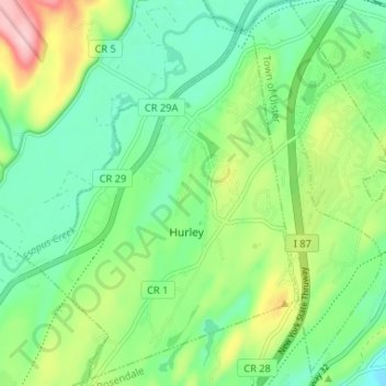
Name: Hurley topographic map, elevation, terrain.
Average elevation: 80 m
Minimum elevation: 18 m
Maximum elevation: 213 m
Make a donation
Other topographic maps
Click on a map to view its topography, its elevation and its terrain.
Mount Marion Park
United States > New York > Ulster County > Town of Saugerties
Average elevation: 75 m
Connelly
United States > New York > Ulster County > Town of Esopus > Port Ewen
Average elevation: 44 m
Make a donation
Overlook Mountain
United States > New York > Ulster County > Town of Woodstock
Average elevation: 661 m
Sojourner Truth State Park
United States > New York > Ulster County > City of Kingston > East Kingston
Average elevation: 38 m
Make a donation
Make a donation
Big Indian Park
United States > New York > Ulster County > Town of Shandaken > Big Indian
Average elevation: 493 m
Make a donation
Mohonk Mountain House Property
United States > New York > Ulster County > Town of New Paltz
Average elevation: 228 m
Bear Hill Preserve (Cragsmoor Free Library)
United States > New York > Ulster County > Town of Wawarsing > Cragsmoor
Average elevation: 414 m
Make a donation
Sam's Point Overlook
United States > New York > Ulster County > Town of Wawarsing > Village of Ellenville
Average elevation: 542 m
Make a donation
West Saugerties
United States > New York > Ulster County > Town of Saugerties
Average elevation: 249 m
Make a donation
Red Hill Fire Tower
United States > New York > Ulster County > Town of Denning
The cabin is a small, one-story, 14-by-24-foot (4.3 by 7.3 m) gable-roofed frame building. It is sided with "brainstorm", edge board stained reddish brown. It has a mortared rubblestone foundation and a covered porch on the south elevation, originally decked in wood but since replaced with concrete. Built in…
Average elevation: 713 m
Frost Valley
United States > New York > Ulster County > Town of Denning > Frost Valley
Average elevation: 735 m
Make a donation