
Cavite topographic map
Interactive map
Click on the map to display elevation.
Cavite
Another theory proposes that the name is a Hispanicized form of kabit, Tagalog for "joined", "connected", or "attached", referring to the peninsula's topographical relation to the mainland. Edmund Roberts, in his 1821 memoir, stated that the "natives" called it Caveit due to the "crooked point of land extending into the sea".
About this map
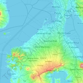
Name: Cavite topographic map, elevation, terrain.
Location: Cavite, Calabarzon, Philippines (14.05990 120.41584 14.58671 121.07768)
Average elevation: 88 m
Minimum elevation: -2 m
Maximum elevation: 1,062 m
Other topographic maps
Click on a map to view its topography, its elevation and its terrain.
Antipolo
Its higher elevation than that of Metro Manila affords it a scenic view of the metropolis, especially at night. Its locally grown mangoes and cashews are popular among tourists, as well as suman – a local delicacy made out of glutinous rice. The Hinulugang Taktak National Park, which was once a popular…
Average elevation: 125 m
Surigao City
Philippines > Surigao del Norte
Surigao City is marked by rolling hills that gently buffers its eastern and western boundaries. To the south-west towers the Kabangkaan Ridge which divides the city from the municipality of San Francisco (formerly Anao-aon). Kinabutan River (otherwise known as Surigao River) meanders Surigao valley before it…
Average elevation: 40 m