Geolocate

Dalälven topographic map

Interactive map

Click on the map to display elevation.

About this map

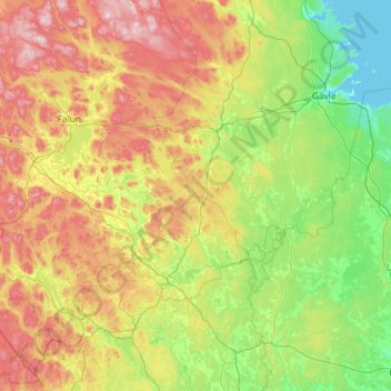
Name: Dalälven topographic map, elevation, terrain.

Location: Dalälven, 784 68, Sweden (60.12115 15.13420 60.64274 17.45586)

Average elevation: 131 m

Minimum elevation: -2 m

Maximum elevation: 491 m

Other topographic maps

Click on a map to view its topography, its elevation and its terrain.

Gothenburg

Sweden > Västra Götaland County

Average elevation: 45 m

Norrköping

Sweden > Östergötland County

Average elevation: 49 m

Västra Kåphult

Sweden > Halland County

Average elevation: 106 m

Partille

Sweden > Västra Götaland County

Average elevation: 80 m

Eskilstuna

Sweden > Södermanland County

Average elevation: 27 m

Kebnekaise

Sweden > Norrbotten County

Average elevation: 1,656 m

Stockholm

Sweden > Stockholm County > Stockholm

Average elevation: 26 m