
Cordillera Administrative Region topographic map
Interactive map
Click on the map to display elevation.
About this map
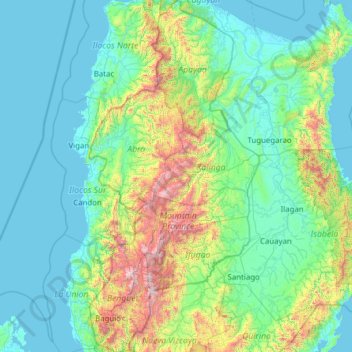
Name: Cordillera Administrative Region topographic map, elevation, terrain.
Location: Cordillera Administrative Region, Philippines (16.18100 120.45971 18.54277 121.65676)
Average elevation: 359 m
Minimum elevation: -2 m
Maximum elevation: 2,848 m
Other topographic maps
Click on a map to view its topography, its elevation and its terrain.
Mount Ampakaw
Philippines > Mountain Province > Pide
Mount Ampakaw, Pide, Mountain Province, Cordillera Administrative Region, 2619, Philippines
Average elevation: 1,598 m
Calapan
Philippines > Oriental Mindoro
Calapan, Oriental Mindoro, Mimaropa, 5200, Philippines
Average elevation: 12 m
Hawilian
Hawilian, Agusan del Sur, Caraga, 8513, Philippines
Average elevation: 20 m
Esperanza
Esperanza, Agusan del Sur, Caraga, 8513, Philippines
Average elevation: 153 m
Parañaque
Parañaque, Southern Manila District, Metro Manila, 1700, Philippines
Average elevation: 11 m
Zamboanga del Norte
Zamboanga del Norte, Zamboanga Peninsula, Philippines
Average elevation: 78 m
Zamboanga del Sur
Zamboanga del Sur, Zamboanga Peninsula, Philippines
Average elevation: 158 m
Malapag
Malapag, North Cotabato, Soccsksargen, Philippines
Average elevation: 185 m
Asipulo
Asipulo, Ifugao, Cordillera Administrative Region, Philippines
Average elevation: 1,050 m
Salitran
Philippines > Cavite > Dasmariñas
Salitran, Dasmariñas, Cavite, Calabarzon, Philippines
Average elevation: 61 m
Bansalan
Bansalan, Davao del Sur, Davao Region, 8005, Philippines
Average elevation: 596 m
Cervantes
Cervantes, Ilocos Sur, Ilocos Region, 2718, Philippines
Average elevation: 610 m
Surigao City
Philippines > Surigao del Norte
Surigao City, Surigao del Norte, Caraga, 8400, Philippines
Average elevation: 40 m
Boac River
Philippines > Marinduque > Boac
Boac River, Boac, 1st District, Marinduque, Mimaropa, 4900, Philippines
Average elevation: 45 m
Pasig
Pasig, Eastern Manila District, Metro Manila, 1600, Philippines
Average elevation: 17 m
Puerto Galera
Philippines > Oriental Mindoro
Puerto Galera, Oriental Mindoro, Mimaropa, Philippines
Average elevation: 442 m
Quezon City
Quezon City, Eastern Manila District, Metro Manila, 1100, Philippines
Average elevation: 39 m
Teguis
Philippines > Cebu > Poro > Teguis
Teguis, Poro, Cebu, Central Visayas, Philippines
Average elevation: 44 m
Valenzuela
Valenzuela, Makati 1st District, Makati, Southern Manila District, Metro Manila, Philippines
Average elevation: 12 m
Palihan
Philippines > Bataan > Palihan
Palihan, Bataan, Central Luzon, 2111, Philippines
Average elevation: 15 m
Ligñon Hill
Philippines > Albay > Legazpi
Ligñon Hill, Legazpi, Albay, Bicol Region, 4500, Philippines
Average elevation: 24 m
Quitinday
Philippines > Albay > Jovellar
Quitinday, Jovellar, Albay, Bicol Region, Philippines
Average elevation: 96 m
Kapuntukan Hill / Sleeping Lion Hill
Philippines > Albay > Legazpi
Kapuntukan Hill / Sleeping Lion Hill, Legazpi, Albay, Bicol Region, 4500, Philippines
Average elevation: 5 m
Santo Tomas
Philippines > Batangas > Santo Tomas
Santo Tomas, Batangas, Calabarzon, 4234, Philippines
Average elevation: 210 m
Trento
Philippines > Agusan del Sur > Trento > Trento
Trento, Agusan del Sur, Caraga, 8505, Philippines
Average elevation: 39 m
Santa Monica
Philippines > Surigao del Norte > Santa Monica
Santa Monica, Surigao del Norte, Caraga, 8422, Philippines
Average elevation: 21 m
Biri
Biri, Northern Samar, Eastern Visayas, Philippines
Average elevation: 1 m
Batasan Hills
Batasan Hills, 2nd District, Quezon City, Second District, Metro Manila, Philippines
Average elevation: 49 m
Ferrol
Philippines > Romblon > Ferrol
Ferrol, Romblon, Mimaropa, 5506, Philippines
Average elevation: 31 m
Cugman
Philippines > Misamis Oriental > Cagayan de Oro > Cugman
Cugman, Cagayan de Oro, Misamis Oriental, Northern Mindanao, Philippines
Average elevation: 52 m
Capoocan
Philippines > Leyte > Capoocan
Capoocan, Leyte 2nd District, Leyte, Eastern Visayas, 6530, Philippines
Average elevation: 139 m
Sapang Dalaga
Philippines > Misamis Occidental > Sapang Dalaga
Sapang Dalaga, Misamis Occidental, Northern Mindanao, Philippines
Average elevation: 100 m
San Juan
Philippines > Ilocos Sur > San Juan
San Juan, Ilocos Sur, Ilocos Region, 2731, Philippines
Average elevation: 37 m
Camiling
Philippines > Tarlac > Camiling
Camiling, Tarlac, Central Luzon, 2306, Philippines
Average elevation: 19 m
Mayantoc
Philippines > Tarlac > Tarlac City > Mayantoc
Mayantoc, Tarlac City, Tarlac, Central Luzon, Philippines
Average elevation: 53 m
Tacloban
Philippines > Leyte > Tacloban
Tacloban, Leyte, Eastern Visayas, 6500, Philippines
Average elevation: 29 m