
Make a donation
Quezon City topographic map
Click on the map to display elevation.
Make a donation
Quezon City
In order to make Quezon's dream a reality and to mobilize funds for the land purchase, the People's Homesite Corporation (PHC) was created on October 14, 1938, as a subsidiary of NDC, with an initial capital of ₱2 million. Roces was the chairman of the Board of PHC, and they immediately acquired the vast Diliman Estate of the Tuason family at a cost of 5 centavos per square meter. PHC conducted topographical and subdivision surveys, and then subdivided the lots and sold them to the target buyers at an affordable price. Its target users and beneficiaries are obviously Manila's working class, who are suffering from the shortage of affordable and decent housing in the capital. The service of the Metropolitan Waterworks system was extended to site. The Bureau of Public Works, then under Secretary Vicente Fragante, constructed the streets and highways within the property. Quezon also tapped Architect Juan M. Arellano to draft a design of the city.
Make a donation
About this map
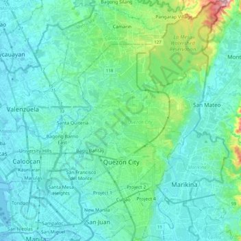
Name: Quezon City topographic map, elevation, terrain.
Average elevation: 39 m
Minimum elevation: -2 m
Maximum elevation: 252 m
Make a donation
Other topographic maps
Click on a map to view its topography, its elevation and its terrain.
Antipolo
Its higher elevation than that of Metro Manila affords it a scenic view of the metropolis, especially at night. Its locally grown mangoes and cashews are popular among tourists, as well as suman – a local delicacy made out of glutinous rice. The Hinulugang Taktak National Park, which was once a popular…
Average elevation: 125 m
Make a donation
Make a donation
Make a donation
Make a donation
Make a donation
Surigao City
Philippines > Surigao del Norte
Surigao City is marked by rolling hills that gently buffers its eastern and western boundaries. To the south-west towers the Kabangkaan Ridge which divides the city from the municipality of San Francisco (formerly Anao-aon). Kinabutan River (otherwise known as Surigao River) meanders Surigao valley before it…
Average elevation: 40 m
Make a donation