
Thank you for supporting this site ❤️
Make a donation
Make a donation
Blekinge County topographic map
Click on the map to display elevation.
Thank you for supporting this site ❤️
Make a donation
Make a donation
About this map
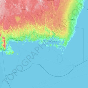
Name: Blekinge County topographic map, elevation, terrain.
Location: Blekinge County, Sweden (55.74669 14.39016 56.50351 16.22367)
Average elevation: 38 m
Minimum elevation: -3 m
Maximum elevation: 203 m
Thank you for supporting this site ❤️
Make a donation
Make a donation
Other topographic maps
Click on a map to view its topography, its elevation and its terrain.