
Thank you for supporting this site ❤️
Make a donation
Make a donation
Flowery Branch topographic map
Click on the map to display elevation.
Thank you for supporting this site ❤️
Make a donation
Make a donation
About this map
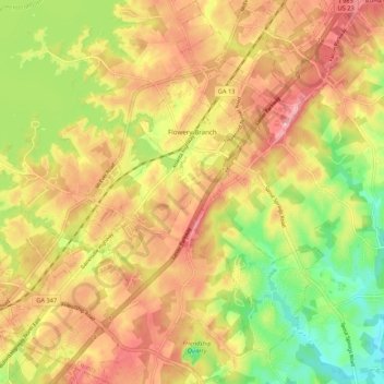
Name: Flowery Branch topographic map, elevation, terrain.
Location: Flowery Branch, Hall County, Georgia, 30542, United States (34.12683 -83.95920 34.21538 -83.88169)
Average elevation: 343 m
Minimum elevation: 259 m
Maximum elevation: 412 m
Thank you for supporting this site ❤️
Make a donation
Make a donation
Other topographic maps
Click on a map to view its topography, its elevation and its terrain.
Thank you for supporting this site ❤️
Make a donation
Make a donation
Thank you for supporting this site ❤️
Make a donation
Make a donation
Thank you for supporting this site ❤️
Make a donation
Make a donation