
Make a donation
Chiang Mai topographic map
Click on the map to display elevation.
Make a donation
Chiang Mai
Chiang Mai has a tropical savanna climate (Köppen Aw), tempered by the low latitude and moderate elevation, with warm to hot weather year-round, though nighttime conditions during the dry season can be cool and much lower than daytime highs. The maximum temperature ever recorded was 42.5 °C (108.5 °F) in May 2016. Cold and hot weather effects occur immediately but cold effects last longer than hot effects and contribute to higher cold related mortality risk among old people aged more than 85 years.
Make a donation
About this map
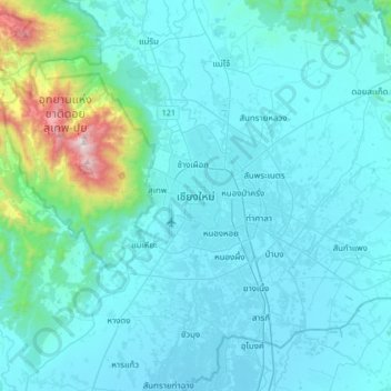
Name: Chiang Mai topographic map, elevation, terrain.
Location: Chiang Mai, Pa Daet, Saraphi District, 55520, Thailand (18.62828 98.82588 18.94828 99.14588)
Average elevation: 424 m
Minimum elevation: 291 m
Maximum elevation: 1,670 m
Make a donation
Other topographic maps
Click on a map to view its topography, its elevation and its terrain.
Make a donation
Prachuap Khiri Khan Province
Prachuap Khiri Khan covers an area totaling 6,367 square kilometers (2,458 sq mi). The province is on the Kra Isthmus, the narrow land bridge connecting the Malay Peninsula with mainland Asia. The province has the narrowest part of Thailand, just 12.38 km (7.69 mi) from the Gulf of Thailand to the border with…
Average elevation: 105 m