
Thank you for supporting this site ❤️
Make a donation
Make a donation
Nakhon Ratchasima Province topographic map
Click on the map to display elevation.
Thank you for supporting this site ❤️
Make a donation
Make a donation
About this map
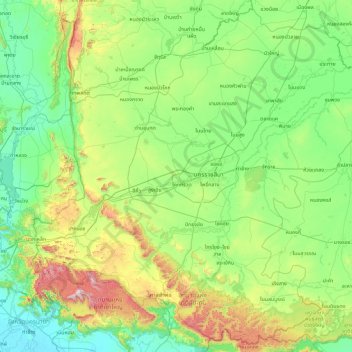
Name: Nakhon Ratchasima Province topographic map, elevation, terrain.
Location: Nakhon Ratchasima Province, Thailand (14.12039 101.18110 15.80812 103.01275)
Average elevation: 247 m
Minimum elevation: 2 m
Maximum elevation: 1,305 m
Thank you for supporting this site ❤️
Make a donation
Make a donation
Other topographic maps
Click on a map to view its topography, its elevation and its terrain.
Chiang Mai
Chiang Mai has a tropical savanna climate (Köppen Aw), tempered by the low latitude and moderate elevation, with warm to hot weather year-round, though nighttime conditions during the dry season can be cool and much lower than daytime highs. The maximum temperature ever recorded was 42.5 °C (108.5 °F) in…
Average elevation: 424 m
Thank you for supporting this site ❤️
Make a donation
Make a donation
Thank you for supporting this site ❤️
Make a donation
Make a donation