
Thank you for supporting this site ❤️
Make a donation
Make a donation
Vänern topographic map
Click on the map to display elevation.
Thank you for supporting this site ❤️
Make a donation
Make a donation
About this map
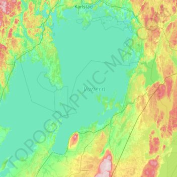
Name: Vänern topographic map, elevation, terrain.
Location: Vänern, 661 91, Sweden (58.35553 12.30780 59.41779 14.15192)
Average elevation: 78 m
Minimum elevation: 40 m
Maximum elevation: 303 m
Thank you for supporting this site ❤️
Make a donation
Make a donation
Other topographic maps
Click on a map to view its topography, its elevation and its terrain.