
查哈阳乡 topographic map
Interactive map
Click on the map to display elevation.
About this map
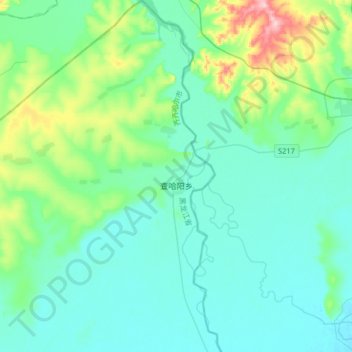
Name: 查哈阳乡 topographic map, elevation, terrain.
Location: 查哈阳乡, 甘南县, 齐齐哈尔市, 黑龙江省, 161000, 中国 (48.31925 124.08746 48.53499 124.32779)
Average elevation: 219 m
Minimum elevation: 184 m
Maximum elevation: 387 m
Other topographic maps
Click on a map to view its topography, its elevation and its terrain.