
齐齐哈尔市 topographic map
Interactive map
Click on the map to display elevation.
About this map
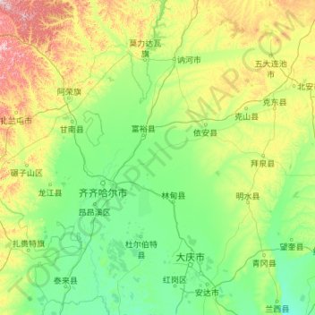
Name: 齐齐哈尔市 topographic map, elevation, terrain.
Location: 齐齐哈尔市, 黑龙江省, 161000, 中国 (46.22093 122.39236 48.92159 126.66072)
Average elevation: 235 m
Minimum elevation: 121 m
Maximum elevation: 1,088 m
齐齐哈尔市地域平坦,土地总面积为42289平方公里,海拔高度一般在200至500米之间,平均海拔146米,东部和南部地势低洼。
Other topographic maps
Click on a map to view its topography, its elevation and its terrain.