
Make a donation
Crete topographic map
Click on the map to display elevation.
Make a donation
Crete
Crete is predominantly mountainous, characterized by a range that crosses the island from west to east. It includes Crete's highest point, Mount Ida, and the range of the White Mountains (Lefka Ori) with 30 summits above 2,000 metres (6,600 ft) in altitude and the Samaria Gorge, a World Biosphere Reserve. Crete forms a significant part of the economy and cultural heritage of Greece, while retaining its own local cultural traits (such as its own poetry and music). The Nikos Kazantzakis airport at Heraklion and the Daskalogiannis airport at Chania serve international travelers. The Minoan palace at Knossos is also located in Heraklion.
Make a donation
About this map
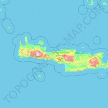
Name: Crete topographic map, elevation, terrain.
Location: Crete, Region of Crete, Greece (34.92121 23.51448 35.69578 26.31897)
Average elevation: 57 m
Minimum elevation: 0 m
Maximum elevation: 2,440 m
Make a donation
Other topographic maps
Click on a map to view its topography, its elevation and its terrain.
Knossos Palace
Greece > Region of Crete > Heraklion Regional Unit > Heraklion Municipal Unit
The identification of Knossos with the Bronze Age site is supported by the Roman coins that were scattered over the fields surrounding the pre-excavation site, then a large mound named Kephala Hill, elevation 85 m (279 ft) from current sea level. Many of them were inscribed with Knosion or Knos on the obverse…
Average elevation: 151 m
Make a donation
Ρίζα
Greece > Region of Crete > Lasithi Regional Unit > Ierapetra Municipal Unit
Average elevation: 553 m
Sisi
Greece > Region of Crete > Lasithi Regional Unit > Vrachasi Municipal Unit
Average elevation: 58 m
Make a donation
Archanes
Greece > Region of Crete > Heraklion Regional Unit > Archanes Municipal Unit
Average elevation: 333 m
Chania
Greece > Region of Crete > Chania Regional Unit
The climate in Chania is further complemented due to the terrain and can vary throughout its regions and elevations and according to its topography. At the south lies the mountain range of Lefka Ori. Furthermore, prevailing winds, such as those of the West side and South of Crete, in addition to the North…
Average elevation: 194 m
Vrachasi
Greece > Region of Crete > Lasithi Regional Unit > Vrachasi Municipal Unit
Average elevation: 363 m
Make a donation
Mátala
Greece > Region of Crete > Heraklion Regional Unit > Tybakio Municipal Unit
Average elevation: 56 m
Charakas
Greece > Region of Crete > Heraklion Regional Unit > Asterousia Municipal Unit
The community of Charakas (Δημοτική Κοινότητα Χάρακος) consists of the village Charakas and the smaller villages Agia Fotia (Αγιά Φωτιά) (pop. 22, at elevation 275 m, 2 km to the West from Charakas) and Doraki (Δωράκι) (pop. 24, at elevation 310 m, 1.5 km to the East from Charakas).
Average elevation: 357 m
Make a donation
Make a donation
Chania
Greece > Region of Crete > Chania Regional Unit
The climate in Chania is further complemented due to the terrain and can vary throughout its regions and elevations and according to its topography. At the south lies the mountain range of Lefka Ori. Furthermore, prevailing winds, such as those of the West side and South of Crete, in addition to the North…
Average elevation: 194 m
Malia
Greece > Region of Crete > Heraklion Regional Unit > Malia Municipal Unit
Average elevation: 199 m
Make a donation
Labyrintaki Cave
Greece > Region of Crete > Heraklion Regional Unit > Mires Municipal Unit
Average elevation: 308 m
Gouves
Greece > Region of Crete > Heraklion Regional Unit > Gouves Municipal Unit
Average elevation: 124 m
Malia
Greece > Region of Crete > Heraklion Regional Unit > Malia Municipal Unit
Average elevation: 199 m
Make a donation
Klima
Greece > Region of Crete > Heraklion Regional Unit > Tybakio Municipal Unit
Average elevation: 176 m
Kalo Chorio
Greece > Region of Crete > Heraklion Regional Unit > Gouves Municipal Unit
Average elevation: 269 m
Demati
Greece > Region of Crete > Heraklion Regional Unit > Arkalochori Municipal Unit
Average elevation: 274 m
Make a donation
Aposelemi
Greece > Region of Crete > Heraklion Regional Unit > Asterousia Municipal Unit
Average elevation: 335 m
Tefeli
Greece > Region of Crete > Heraklion Regional Unit > Asterousia Municipal Unit
Average elevation: 350 m
Make a donation
Kastelli
Greece > Region of Crete > Heraklion Regional Unit > Kastelli Municipal Unit
Average elevation: 366 m
Milatos
Greece > Region of Crete > Lasithi Regional Unit > Neapoli Municipal Unit
Average elevation: 125 m
Nea Alikarnassos
Greece > Region of Crete > Heraklion Regional Unit > Nea Alikarnassos Municipal Unit
Average elevation: 30 m
Make a donation
Kastelli
Greece > Region of Crete > Heraklion Regional Unit > Kastelli Municipal Unit
Average elevation: 366 m
Make a donation
Malia
Greece > Region of Crete > Heraklion Regional Unit > Malia Municipal Unit
Average elevation: 199 m
Make a donation
Kokkini Chani
Greece > Region of Crete > Heraklion Regional Unit > Gouves Municipal Unit
Average elevation: 45 m
Myli Gorge
Greece > Region of Crete > Rethymno Regional Unit > Xiro Chorio > Myli
Average elevation: 198 m
Piskopiano
Greece > Region of Crete > Heraklion Regional Unit > Chersonisos Municipal Unit
Average elevation: 139 m
Make a donation
Meskla
Greece > Region of Crete > Chania Regional Unit
Meskla (Μεσκλά) is a village in the municipality of Platanias, a regional unit of Chania, western Crete, in Greece. According to the 2021 census it has 268 inhabitants. It is built on an altitude of 200 meters, at the northern foothills of the White Mountains, in the valley of the river Keritis. It is 21…
Average elevation: 422 m
Make a donation
Chania
Greece > Region of Crete > Chania Regional Unit
The climate in Chania is further complemented due to the terrain and can vary throughout its regions and elevations and according to its topography. At the south lies the mountain range of Lefka Ori. Furthermore, prevailing winds, such as those of the West side and South of Crete, in addition to the North…
Average elevation: 194 m
Larani
Greece > Region of Crete > Heraklion Regional Unit > Agia Varvava Municipal Unit
Average elevation: 469 m
Make a donation
Tris Ekklisies
Greece > Region of Crete > Heraklion Regional Unit > Asterousia Municipal Unit
Average elevation: 223 m
Bethlehem Gate
Greece > Region of Crete > Heraklion Regional Unit > Heraklion Municipal Unit
Average elevation: 32 m
Make a donation
Stavromenos
Greece > Region of Crete > Lasithi Regional Unit > Sitia Municipal Unit
Average elevation: 297 m
Make a donation
Tsifliki
Greece > Region of Crete > Lasithi Regional Unit > Agios Nikolaos Municipal Unit
Average elevation: 107 m
Galia
Greece > Region of Crete > Heraklion Regional Unit > Mires Municipal Unit
It lies at an altitude of 250 metres (820 ft), surrounded by hills. It commands an imposing view south to the Messara Plain and to the Asterousia mountain range, west to the Libyan Sea and north to the Psiloritis mountain. It has 833 residents (2021), mainly farmers.
Average elevation: 227 m
Archontiko
Greece > Region of Crete > Heraklion Regional Unit > Arkalochori Municipal Unit
Average elevation: 381 m
Make a donation
Apostoli
Greece > Region of Crete > Heraklion Regional Unit > Kastelli Municipal Unit
Average elevation: 387 m
Make a donation
Lentas
Greece > Region of Crete > Heraklion Regional Unit > Gortyna Municipal Unit
Average elevation: 97 m
Make a donation
Make a donation
Make a donation
Roustika
Greece > Region of Crete > Rethymno Regional Unit
Roustika is located twenty kilometers southwest of Rethymno at an altitude of 290 m at the foot of the hill Ambelos. Roustika existed before the conquest of Crete by the Venetians. The name could originate from the Arabic word Roustak (which means: village) and it is believed that the Venetians adapted the…
Average elevation: 297 m
Make a donation
Pyrgou
Greece > Region of Crete > Heraklion Regional Unit > Gorgolaini Municipal Unit
Average elevation: 326 m
Make a donation
Bethlehem Gate
Greece > Region of Crete > Heraklion Regional Unit > Heraklion Municipal Unit
Average elevation: 32 m
Make a donation