
Syria topographic map
Click on the map to display elevation.
About this map
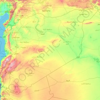
Name: Syria topographic map, elevation, terrain.
Location: Syria (32.31176 35.47144 37.31868 42.37459)
Average elevation: 537 m
Minimum elevation: -216 m
Maximum elevation: 2,960 m
Other topographic maps
Click on a map to view its topography, its elevation and its terrain.
Tiberias
Tiberias is located on the shore of the Sea of Galilee and the western slopes of the Jordan Rift Valley overlooking the lake, in the elevation range of −200 to 200 metres (−660–660 feet). Tiberias has a climate that borders a Hot-summer Mediterranean climate (koppen Csa) and a Hot Semi-arid climate…
Average elevation: -78 m
Golan Heights
The plateau that Israel controls is part of a larger area of volcanic basalt fields stretching north and east that were created in a series of volcanic eruptions that began recently in geological terms, almost 4 million years ago. The rock forming the mountainous area in the northern Golan Heights, descending…
Average elevation: 406 m
Kiryat Shmona
Kiryat Shmona is located in the Finger of the Galilee next to Hula Valley, about 5 kilometres (3 miles) south and 2 km (1 mile) east of the Israel–Lebanon border. Its elevation is about 150 metres (492 feet) above sea level.
Average elevation: 236 m
Modiin-Maccabim-Reut
הנחלים HaNechalim – The Rivers (Safdie) and משואה Masuah – Beacon (Givat C) are located towards the west of the city, and were planned by architect Moshe Safdie. Located in these neighborhoods are five commercial centers, a secondary school and three primary schools. The central street names are…
Average elevation: 240 m
Mitzpe Ramon
Mitzpe Ramon (Hebrew: מִצְפֵּה רָמוֹן, Ramon Lookout; Arabic: متسبي رمون) is a local council in the Negev desert of southern Israel. It is situated on the northern ridge at an elevation of 860 meters (2,800 feet) overlooking the world's largest erosion cirque, known as the Makhtesh…
Average elevation: 782 m
Nimrod Fortress National Park
Israel > North District > Golan Regional Council
Average elevation: 674 m
Caesarea National Park
Israel > Haifa District > Hof HaCarmel Regional Council > Caesarea
Average elevation: 8 m
Nahal Taninim
Israel > Haifa District > Hof HaCarmel Regional Council > Caesarea
Average elevation: 32 m
Matmor Mountains lookout
Israel > South District > Ramat Negev Regional Council
Average elevation: 410 m
Har Bental
Israel > North District > Golan Regional Council
Mount Bental (Arabic: جبل بنطل, جبل الغرام / ALA-LC: Jabal al-Gharam / "Mountain of Lust" "Jabal Bental"; Hebrew: הר בנטל, Har Bental, "Mount Bental" (lit. "Son of Dew") is a dormant volcano in the North-Eastern part of the Golan Heights, It extends to an elevation of 1,171 meters above sea level.
Average elevation: 975 m
Mount Meron
Israel > North District > Merom HaGalil Regional Council
In 1965, an 84,000-dunam nature reserve was declared. An additional 1,199 dunams were declared part of the reserve in 2005. It is the highest reserve in Israel, at an altitude of 1,204 meters above sea level, and the largest reserve in the north of the country.
Average elevation: 943 m
2236 Mt. Hermon
Israel > North District > Golan Regional Council
Mount Hermon (Arabic: جبل الشيخ or جبل حرمون / ALA-LC: Jabal al-Shaykh ('Mountain of the Sheikh') or Jabal Haramun; Hebrew: הַר חֶרְמוֹן, Har Ḥermōn) is a mountain cluster constituting the southern end of the Anti-Lebanon mountain range. Its summit straddles the border between…
Average elevation: 2,016 m
Nkowankowa
South Africa > Limpopo > Mopani District Municipality > Greater Tzaneen Local Municipality
Average elevation: 544 m
Mestia
Georgia > Samegrelo-Upper Svaneti > Mestia Municipality
Mestia (Georgian: მესტია IPA: [mɛstʼiɑ]) is a highland townlet (daba) in northwest Georgia, at an elevation of 1,500 metres (4,921 feet) in the Caucasus Mountains.
Average elevation: 1,770 m
Qizilqum - Qızılqum - Қызылқұм - Gyzylgum
Kyzylkum is mainly located in Uzbekistan. Its territory consists mainly of an extensive plain at an altitude up to 300 m (980 ft) above sea level, with a number of depressions and highlands (Sultanuizdag, Bukantau). Most of the area is covered with dunes (barchans); in the northwest large areas are covered…
Average elevation: 367 m
Farellones
Chile > Santiago Metropolitan Region > Provincia de Santiago
Located in the commune of Lo Barnechea, 36 km from Santiago at an altitude of 2,340 meters above sea level (7,874 feet), Farellones has a health centre, a school, and about 200 houses. The houses and cabins are made of wood, giving the village its characteristic look.
Average elevation: 2,243 m
Pretoria
South Africa > Gauteng > City of Tshwane Metropolitan Municipality
Pretoria is situated approximately 56 km (35 mi) north-northeast of Johannesburg in the northeast of South Africa, in a transitional belt between the plateau of the Highveld to the south and the lower-lying Bushveld to the north. It lies at an altitude of about 1,339 m (4,393 ft) above sea level, in a warm,…
Average elevation: 1,363 m