
Make a donation
United Kingdom topographic map
Click on the map to display elevation.
Make a donation
United Kingdom
The United Kingdom (UK) boasts a diverse topography, ranging from rugged highlands to gentle lowlands. In Scotland, the Highlands dominate the northern and western regions, featuring mountainous terrains with peaks like Ben Nevis, the UK's highest point at 1,345 meters (4,413 feet). The Central Lowlands, including the valleys of the Tay, Forth, and Clyde rivers, offer flatter landscapes. Wales is predominantly mountainous, especially in the north and central areas, with the Cambrian Mountains and Snowdonia National Park housing peaks such as Snowdon at 1,085 meters (3,560 feet). England's topography is characterized by the Pennines, often referred to as the "backbone of England," running north to south, and the Lake District in the northwest, home to Scafell Pike, the highest point in England at 978 meters (3,209 feet). Northern Ireland features the Mourne Mountains in the southeast, with Slieve Donard reaching 852 meters (2,795 feet), and the expansive Lough Neagh, the largest lake in the UK. The UK's varied terrain, including extensive coastlines, rolling hills, and fertile plains, contributes to its rich natural beauty and ecological diversity.
Make a donation
About this map
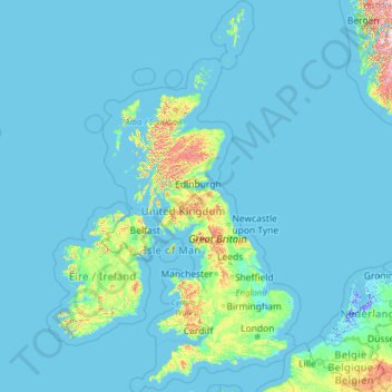
Name: United Kingdom topographic map, elevation, terrain.
Location: United Kingdom (49.67400 -14.01552 61.06100 2.09191)
Average elevation: 42 m
Minimum elevation: -6 m
Maximum elevation: 1,617 m
Make a donation
Other topographic maps
Click on a map to view its topography, its elevation and its terrain.
Tagherouba
Morocco > Tangier-Tetouan-Al Hoceima > Cercle de Kétama > Moulay Ahmed Cherif
Average elevation: 1,477 m
Make a donation
Eretria
Greece > Central Greece > Euboea Regional Unit > Eretria Municipal Unit
Average elevation: 45 m
Roodepoort
South Africa > Gauteng > City of Johannesburg Metropolitan Municipality
Average elevation: 1,594 m
Make a donation
Damavand
Iran > Mazandaran Province > Amol County > دهستان لاریجان سفلی
Mount Damavand (Persian: دماوند [dæmɒːvænd] ) is a dormant stratovolcano and is the highest peak in Iran and Western Asia, the highest volcano in Asia, and the 3rd highest volcano in the Eastern Hemisphere (after Mount Kilimanjaro and Mount Elbrus), at an elevation of 5,609 metres (18,402 ft).…
Average elevation: 4,949 m
Make a donation
Make a donation
Tochal
Iran > Tehran Province > Shemiranat County > دهستان رودبار قصران
Tochal (Persian: توچال Točāl), is a mountain and ski resort located on the Alborz mountain range, adjacent to the metropolitan area of Tehran in northern Iran. It includes a 12-kilometre-long (7.5 mi) ridge. Its highest peak, also called Tochal, is at an elevation of 3,963 metres (13,002 ft) above sea level.
Average elevation: 3,561 m
Ilha Sumítica
Brazil > São Paulo > Região Metropolitana do Vale do Paraíba e Litoral Norte > Ilhabela
Average elevation: 1 m
Make a donation
Make a donation
Mtkvari
Georgia > Shida Kartli > Khashuri Municipality > Rbona
Most of the Kura runs in the broad and deep valley between the Greater Caucasus and Lesser Caucasus Mountains, and the major tributary, the Aras, drains most of the southern Caucasus and the mountain ranges of the extreme northern Middle East. The entirety of Armenia and most of Azerbaijan are drained by the…
Average elevation: 781 m
Neftchala
Throughout its history, Neftçala has suffered from floods because of its proximity to the river and most of the town's relatively low elevation.
Average elevation: -27 m
Make a donation
Homesh
Palestinian Territories > Judea and Samaria > Area C > Shomron Regional Council
Average elevation: 452 m
Make a donation
Austin
United States > Nevada > Lander County
Austin is an unincorporated small town in, and former county seat of, Lander County, Nevada, United States. In 2020, the census-designated place of Austin had a population of 167. It is located on the western slopes of the Toiyabe Range at an elevation of 6,575 feet (2,004 m). U.S. Route 50 passes through the…
Average elevation: 2,061 m
Make a donation
Make a donation
Sanur
Palestinian Territory > Area A
Sanur is located in the highlands of the northern West Bank. The village is situated on an isolated hilltop along the western edge of the valley and seasonal lake of Marj Sanur, which is named after the village. To the west, Sanur is connected to the Hawarah Ridge of the Zawiya Highlands through a low-lying…
Average elevation: 423 m
Make a donation
Isleworth
Elevations range from 27 m (89 ft) in the northwest to 4.9 m (16 ft) by the Thames at the opposite extreme OD. The boundaries are longstanding, subject to twentieth-century western and southern circonscriptions: Isleworth is east of the town of Hounslow which has more retail and offices, in the borough of that…
Average elevation: 19 m
Mullet Lake Village Boating Access Site
United States > Michigan > Cheboygan County > Inverness Township
Average elevation: 185 m
Africa
Average elevation: 462 m
Make a donation
Make a donation
Vryburg
South Africa > North West > Dr Ruth Segomotsi Mompati District Municipality > Naledi Local Municipality
Average elevation: 1,205 m
Make a donation
Puerto Natales
Chile > Magallanes and Chilean Antarctica Region > Provincia de Última Esperanza
Average elevation: 141 m
Make a donation
Make a donation
Baltic Sea
Average elevation: 0 m
Make a donation
Waterton Park
Canada > Alberta > Improvement District No. 04
It is located at the southwestern terminus of Highway 5, approximately 54 kilometres (34 mi) west of the Town of Cardston and 55 kilometres (34 mi) south of the Town of Pincher Creek. This hamlet is north of Glacier National Park in Montana. It has an elevation of 1,280 metres (4,200 ft).
Average elevation: 1,456 m
Make a donation
Make a donation
Elk Grove
United States > Pennsylvania > Columbia County > Sugarloaf Township
Average elevation: 534 m
Make a donation