
通辽市 topographic map
Interactive map
Click on the map to display elevation.
About this map
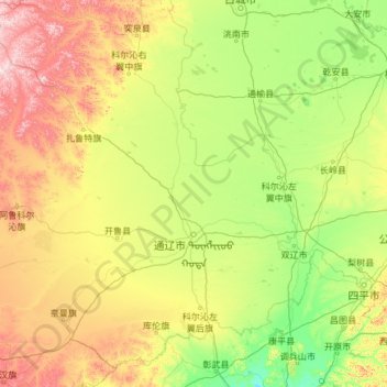
Name: 通辽市 topographic map, elevation, terrain.
Location: 通辽市, 内蒙古自治区, 中国 (42.24027 119.23521 45.68146 123.71518)
Average elevation: 262 m
Minimum elevation: 44 m
Maximum elevation: 1,241 m
通辽市地势南部和北部高,中部低平,呈马鞍形。北部为大兴安岭南麓余脉的石质山地丘陵,占全市总面积的22.8%,海拔高度400-1300m;南部为辽西山地边缘的浅山、黄土丘陵区,占全市总面积的7.0%,海拔高度550-730m;中部为西辽河流域沙质冲积平原,占全市总面积的70.7%,海拔高度120-320m,其中在西辽河流域冲积平原与山地、丘陵之间的过渡地带分布着起伏不平的沙丘和沙地,海拔高度200-400m。
Other topographic maps
Click on a map to view its topography, its elevation and its terrain.