Israel topographic map
Click on the map to display elevation.
Israel
Israel's topography is strikingly diverse, encompassing a variety of landscapes within its relatively small area of approximately 8,522 square miles (22,072 Km²). The coastal plain stretches along the Mediterranean Sea, characterized by sandy shores and fertile land that supports extensive agriculture, particularly in the central regions near cities like Tel Aviv and Haifa. East of this plain rises the Central Highlands, which includes the mountainous terrains of the Galilee and the Judean Hills. Here, elevations peak at about 3,963 feet (1,208 meters) at Mount Meron, interspersed with lush valleys such as the Jezreel Valley, known for its rich agricultural soil. The Jordan Rift Valley, a major geological feature, runs along the eastern border and includes the Jordan River, Lake Tiberias, and the Dead Sea, the latter being the lowest point on Earth's surface at around 1,312 feet (400 meters) below sea level. Southward lies the Negev Desert, which covers over half of Israel's land area and features arid landscapes, rocky canyons, and unique geological formations. This combination of coastal, highland, valley, and desert terrains not only shapes the geography but also influences the climate and biodiversity across the country.
About this map
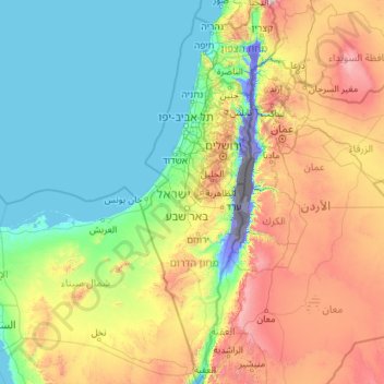
Name: Israel topographic map, elevation, terrain.
Location: Israel (29.45338 34.26750 33.33563 35.89502)
Average elevation: 410 m
Minimum elevation: -415 m
Maximum elevation: 2,320 m
Other topographic maps
Click on a map to view its topography, its elevation and its terrain.
Golan Heights
The plateau that Israel controls is part of a larger area of volcanic basalt fields stretching north and east that were created in a series of volcanic eruptions that began recently in geological terms, almost 4 million years ago. The rock forming the mountainous area in the northern Golan Heights, descending…
Average elevation: 406 m




Nimrod Fortress National Park
Israel > North District > Golan Regional Council
Average elevation: 674 m



Modiin-Maccabim-Reut
הנחלים HaNechalim – The Rivers (Safdie) and משואה Masuah – Beacon (Givat C) are located towards the west of the city, and were planned by architect Moshe Safdie. Located in these neighborhoods are five commercial centers, a secondary school and three primary schools. The central street names are…
Average elevation: 240 m
Kiryat Shmona
Kiryat Shmona is located in the Finger of the Galilee next to Hula Valley, about 5 kilometres (3 miles) south and 2 km (1 mile) east of the Israel–Lebanon border. Its elevation is about 150 metres (492 feet) above sea level.
Average elevation: 236 m
Tiberias
Tiberias is located on the shore of the Sea of Galilee and the western slopes of the Jordan Rift Valley overlooking the lake, in the elevation range of −200 to 200 metres (−660–660 feet). Tiberias has a climate that borders a Hot-summer Mediterranean climate (koppen Csa) and a Hot Semi-arid climate…
Average elevation: -78 m
Mitzpe Ramon
Mitzpe Ramon (Hebrew: מִצְפֵּה רָמוֹן, Ramon Lookout; Arabic: متسبي رمون) is a local council in the Negev desert of southern Israel. It is situated on the northern ridge at an elevation of 860 meters (2,800 feet) overlooking the world's largest erosion cirque, known as the Makhtesh…
Average elevation: 782 m







Caesarea National Park
Israel > Haifa District > Hof HaCarmel Regional Council > Caesarea
Average elevation: 8 m



Nahal Taninim
Israel > Haifa District > Hof HaCarmel Regional Council > Caesarea
Average elevation: 32 m


Matmor Mountains lookout
Israel > South District > Ramat Negev Regional Council
Average elevation: 410 m


Har Bental
Israel > North District > Golan Regional Council
Mount Bental (Arabic: جبل بنطل, جبل الغرام / ALA-LC: Jabal al-Gharam / "Mountain of Lust" "Jabal Bental"; Hebrew: הר בנטל, Har Bental, "Mount Bental" (lit. "Son of Dew") is a dormant volcano in the North-Eastern part of the Golan Heights, It extends to an elevation of 1,171 meters above sea level.
Average elevation: 975 m
Mount Meron
Israel > North District > Merom HaGalil Regional Council
In 1965, an 84,000-dunam nature reserve was declared. An additional 1,199 dunams were declared part of the reserve in 2005. It is the highest reserve in Israel, at an altitude of 1,204 meters above sea level, and the largest reserve in the north of the country.
Average elevation: 943 m


2236 Mt. Hermon
Israel > North District > Golan Regional Council
Mount Hermon (Arabic: جبل الشيخ or جبل حرمون / ALA-LC: Jabal al-Shaykh ('Mountain of the Sheikh') or Jabal Haramun; Hebrew: הַר חֶרְמוֹן, Har Ḥermōn) is a mountain cluster constituting the southern end of the Anti-Lebanon mountain range. Its summit straddles the border between…
Average elevation: 2,016 m



Nafplio
Greece > Peloponnese Region > Argolis Regional Unit > Municipal Unit of Nafplio
Average elevation: 36 m






Schalders - Scaleres
Italy > Trentino – Alto Adige/Südtirol > South Tyrol > Vahrn - Varna
Average elevation: 1,484 m