
Madagascar topographic map
Interactive map
Click on the map to display elevation.
About this map
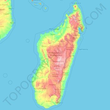
Name: Madagascar topographic map, elevation, terrain.
Location: Madagascar (-25.78402 42.96801 -11.73289 50.67273)
Average elevation: 139 m
Minimum elevation: -1 m
Maximum elevation: 2,568 m
The prehistoric breakup of the supercontinent Gondwana resulted in the separation of East Gondwana (comprising Madagascar, Antarctica, Australia and the Indian subcontinent) and West Gondwana (Africa–South America) during the Jurassic period, around 185 million years ago. The Indo-Madagascar landmass separated from Antarctica and Australia around 125 million years ago and Madagascar separated from the Indian landmass about 84–92 million years ago during the Late Cretaceous. This long history of separation from other continents has allowed plants and animals on the island to evolve in relative isolation. Along the length of the eastern coast runs a narrow and steep escarpment containing much of the island's remaining tropical lowland forest. To the west of this ridge lies a plateau in the center of the island ranging in altitude from 750 to 1,500 m (2,460 to 4,920 ft) above sea level. These central highlands, traditionally the homeland of the Merina people and the location of their historic capital at Antananarivo, are the most densely populated part of the island and are characterized by terraced, rice-growing valleys lying between grassy hills and patches of the subhumid forests that formerly covered the highland region. To the west of the highlands, the increasingly arid terrain gradually slopes down to the Mozambique Channel and mangrove swamps along the coast.
Other topographic maps
Click on a map to view its topography, its elevation and its terrain.
Kiryat Shmona
Kiryat Shmona, Safed Subdistrict, North District, Israel
Average elevation: 237 m
Romania
Romania
Average elevation: 355 m
El Paso
United States > Texas > El Paso County
El Paso, El Paso County, Texas, United States
Average elevation: 1,235 m
Omaha
United States > Nebraska > Douglas County
Omaha, Douglas County, Nebraska, United States
Average elevation: 338 m
Butler
Butler, Butler County, Pennsylvania, 16003, United States
Average elevation: 339 m
Elizabeth Bay
Australia > New South Wales > Sydney
Elizabeth Bay, Sydney, Council of the City of Sydney, New South Wales, 2011, Australia
Average elevation: 22 m
Golan heights
Golan heights, Golan Subdistrict, North District, Israel
Average elevation: 542 m
Cheyenne
United States > Wyoming > Laramie County
Cheyenne, Laramie County, Wyoming, United States
Average elevation: 1,871 m
Kota Kinabalu
Kota Kinabalu, West Coast Division, Sabah, 88000, Malaysia
Average elevation: 86 m
Thiva
Greece > Thessaly and Central Greece > Regional Unit of Boeotia > Municipal Unit of Thebes
Thiva, Municipal Unit of Thebes, Municipality of Thiva, Regional Unit of Boeotia, Central Greece, Thessaly and Central Greece, 322 00, Greece
Average elevation: 218 m
Annaburg
Germany > Saxony-Anhalt > Wittenberg
Annaburg, Wittenberg, Saxony-Anhalt, 06925, Germany
Average elevation: 80 m
Modiin-Maccabim-Reut
Modiin-Maccabim-Reut, Ramla Subdistrict, Center District, Israel
Average elevation: 240 m
Bošnjaci
Croatia > Vukovar-Srijem County
Bošnjaci, Općina Bošnjaci, Vukovar-Srijem County, 32275, Croatia
Average elevation: 82 m
Port Moody
Canada > British Columbia > Metro Vancouver Regional District
Port Moody, Metro Vancouver Regional District, British Columbia, Canada
Average elevation: 189 m
Manchester
Manchester, Greater Manchester, England, United Kingdom
Average elevation: 66 m
Village of Bronxville
United States > New York > Westchester County > Town of Eastchester
Village of Bronxville, Town of Eastchester, Westchester County, New York, 10708, United States
Average elevation: 48 m
Muskwa Ranges
Canada > British Columbia > Peace River Regional District > Area B (Finlay Valley/Beatton Valley)
Muskwa Ranges, Area B (Finlay Valley/Beatton Valley), Peace River Regional District, British Columbia, Canada
Average elevation: 1,398 m
Andorra
Andorra
Average elevation: 2,084 m
Valtesiniko
Greece > Peloponnese, Western Greece and the Ionian > Arcadia Regional Unit > Municipal Unit of Kleitor
Valtesiniko, Municipal Unit of Kleitor, Municipality of Gortynia, Arcadia Regional Unit, Peloponnese Region, Peloponnese, Western Greece and the Ionian, 220 14, Greece
Average elevation: 1,115 m
Armenia
Armenia
Average elevation: 1,733 m
Harish
Harish, Hadera Subdistrict, Haifa District, Israel
Average elevation: 105 m
Kiryat Shmona
Kiryat Shmona, Safed Subdistrict, North District, Israel
Average elevation: 236 m
Thorndale
United States > Texas > Milam County
Thorndale, Milam County, Texas, United States
Average elevation: 135 m
Misgav Regional Council
Misgav Regional Council, Acre Subdistrict, North District, Israel
Average elevation: 198 m
Southend-on-Sea
United Kingdom > England > Essex
Southend-on-Sea, Essex, England, SS1 1JX, United Kingdom
Average elevation: 12 m
Efrat
Palestinian Territories > Judea and Samaria > Area C
Efrat, Area C, Judea and Samaria, Palestinian Territories
Average elevation: 898 m
Emek HaMaayanot Regional Council
Emek HaMaayanot Regional Council, Jezreel Subdistrict, North District, Israel
Average elevation: 40 m
Georgetown Charter Township
United States > Michigan > Ottawa County
Georgetown Charter Township, Ottawa County, Michigan, 49428, United States
Average elevation: 199 m
Bochalema
Bochalema, Suroriente, Norte de Santander, RAP Gran Santander, Colombia
Average elevation: 1,395 m
Elsinore
Denmark > Capital Region of Denmark
Elsinore, Helsingør Municipality, Capital Region of Denmark, 3000, Denmark
Average elevation: 11 m
El Talco
Mexico > Nuevo León > Aramberri > La Florida
El Talco, La Florida, Aramberri, Nuevo León, Mexico
Average elevation: 1,166 m
Israel
Israel
Average elevation: 410 m
Metula
Metula, Safed Subdistrict, North District, 1029200, Israel
Average elevation: 484 m
Zilshausen
Germany > Rhineland-Palatinate > Rhein-Hunsrück-Kreis
Zilshausen, Kastellaun, Rhein-Hunsrück-Kreis, Rhineland-Palatinate, Germany
Average elevation: 327 m
Jinniu District
Jinniu District, Chengdu, High-Tech Zone (West), Sichuan, China
Average elevation: 512 m
Holon
Holon, Tel Aviv Subdistrict, Tel-Aviv District, Israel
Average elevation: 33 m
Ashkelon
Ashkelon, Ashkelon Subdistrict, South District, Israel
Average elevation: 31 m