
正蓝旗 topographic map
Interactive map
Click on the map to display elevation.
About this map
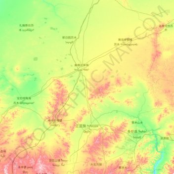
Name: 正蓝旗 topographic map, elevation, terrain.
Location: 正蓝旗, 锡林郭勒盟, 内蒙古自治区, 中国 (41.92581 115.00076 43.13578 116.66795)
Average elevation: 1,339 m
Minimum elevation: 1,150 m
Maximum elevation: 1,764 m
Other topographic maps
Click on a map to view its topography, its elevation and its terrain.