
Denmark topographic map
Interactive map
Click on the map to display elevation.
About this map
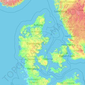
Name: Denmark topographic map, elevation, terrain.
Location: Denmark (54.45167 7.71533 57.95243 15.55306)
Average elevation: 30 m
Minimum elevation: -5 m
Maximum elevation: 596 m
As of 2013, the Kingdom of Denmark, including the Faroe Islands and Greenland, has a total of 1,419 islands above 100 square metres (1,100 sq ft); 443 of which have been named and of which 78 are inhabited. Spanning a total area of 42,943 km2 (16,580 sq mi), metropolitan Denmark consists of the northern part of the Jutland peninsula and an archipelago of 406 islands. Of these, the most populated island is Zealand, on which the capital Copenhagen is situated, followed by Funen, the North Jutlandic Island, and Amager. Denmark's geography is characterised by flat, arable land, sandy coasts, low elevation, and a temperate climate. It had a population of 5.935 million (1 February 2023), of which 800,000 (2 million in the wider area) live in the capital and largest city, Copenhagen. Denmark exercises hegemonic influence in the Danish Realm, devolving powers to handle internal affairs. Home rule was established in the Faroe Islands in 1948 and in Greenland in 1979; the latter obtained further autonomy in 2009.
Other topographic maps
Click on a map to view its topography, its elevation and its terrain.
South Lebanon
United States > Ohio > Warren County
South Lebanon, Warren County, Ohio, 45065, United States
Average elevation: 219 m
Kalyan-Dombivli
India > Maharashtra > Kalyan Taluka
Kalyan-Dombivli, Kalyan Taluka, Thane District, Maharashtra, India
Average elevation: 25 m
Sri Lanka
Sri Lanka
Average elevation: 50 m
Motta Santa Lucia
Motta Santa Lucia, Catanzaro, Calabria, Italy
Average elevation: 662 m
Lubbock
United States > Texas > Lubbock County
Lubbock, Lubbock County, Texas, United States
Average elevation: 983 m
Iran
Iran
Average elevation: 786 m
Bikaner
India > Rajasthan > Bikaner Tehsil
Bikaner, Bikaner Tehsil, Bikaner District, Rajasthan, 334001, India
Average elevation: 225 m
Liberty Township
United States > Ohio > Butler County
Liberty Township, Butler County, Ohio, United States
Average elevation: 233 m
Viljoenskroon
South Africa > Free State > Fezile Dabi District Municipality > Moqhaka Local Municipality
Viljoenskroon, Moqhaka Local Municipality, Fezile Dabi District Municipality, Free State, South Africa
Average elevation: 1,335 m
Gokyo Ri
Nepal > Koshi Province > Solukhumbu
Gokyo Ri, Khumbupasanglahmu, Solukhumbu, Koshi Province, Nepal
Average elevation: 4,968 m
Kyrgyzstan
Kyrgyzstan
Average elevation: 1,973 m
Gualeguaychu
Argentina > Entre Ríos Province > Distrito Costa Uruguay Sur
Gualeguaychu, Gualeguaychú, Distrito Costa Uruguay Sur, Departamento Gualeguaychú, Entre Ríos Province, Argentina
Average elevation: 12 m
Nepal
Nepal
Average elevation: 2,591 m
Germany
Germany
Average elevation: 237 m
Elbląg
Poland > Warmian-Masurian Voivodeship > Elbląg County > Elbląg
Elbląg, gmina Elbląg, Elbląg County, Warmian-Masurian Voivodeship, Poland
Average elevation: 36 m
Campton Township
United States > Illinois > Kane County
Campton Township, Kane County, Illinois, United States
Average elevation: 267 m
Tameslouht
Morocco > Cercle de Tahannaout دائرة تحناوت
Tameslouht, caïdat de Tameslouhte, Cercle de Tahannaout دائرة تحناوت, Al Haouz Province, Marrakech-Safi, 42312, Morocco
Average elevation: 627 m
Hadera
Hadera, Hadera Subdistrict, Haifa District, Israel
Average elevation: 20 m
Myślęcin
Poland > Warmian-Masurian Voivodeship > Elbląg County
Myślęcin, gmina Elbląg, Elbląg County, Warmian-Masurian Voivodeship, Poland
Average elevation: 33 m
Steventon
United Kingdom > England > Hampshire > Basingstoke and Deane
Steventon, Basingstoke and Deane, Hampshire, England, United Kingdom
Average elevation: 134 m
Sheffield
Sheffield, South Yorkshire, England, United Kingdom
Average elevation: 168 m
Emek Izrael Regional Council
Emek Izrael Regional Council, Jezreel Subdistrict, North District, 3657700, Israel
Average elevation: 158 m
Rila mountain range
Rila mountain range, Samokov, Sofia, Bulgaria
Average elevation: 2,525 m
Haddon Hill
Sri Lanka > Central Province > Nuwara Eliya
Haddon Hill, Nuwara Eliya, Nuwara Eliya District, Central Province, 22200, Sri Lanka
Average elevation: 1,968 m
Chester
United Kingdom > England > Cheshire West and Chester
Chester, Cheshire West and Chester, England, CH1 2ET, United Kingdom
Average elevation: 61 m
Dijon
France > Bourgogne-Franche-Comté > Côte-d'Or
Dijon, Côte-d'Or, Bourgogne-Franche-Comté, Metropolitan France, 21000, France
Average elevation: 275 m
Marystown
Canada > Newfoundland and Labrador
Marystown, Newfoundland, Newfoundland and Labrador, A0E 2M0, Canada
Average elevation: 52 m
Loriol-sur-Drôme
France > Auvergne-Rhône-Alpes > Drôme
Loriol-sur-Drôme, Die, Drôme, Auvergne-Rhône-Alpes, Metropolitan France, 26270, France
Average elevation: 158 m
Mercury
United States > Nevada > Nye County
Mercury, Nye County, Nevada, 89023, United States
Average elevation: 1,183 m
Grantsburg
United States > Illinois > Johnson County
Grantsburg, Johnson County, Illinois, 62943, United States
Average elevation: 121 m
Kaddarim
Israel > North District > Galil Elyon Regional Council
Kaddarim, Galil Elyon Regional Council, Safed Subdistrict, North District, Israel
Average elevation: 78 m
Louisville
United States > Kentucky > Jefferson County
Louisville, Jefferson County, Kentucky, United States
Average elevation: 188 m
Hod HaSharon
Hod HaSharon, Petah Tikva Subdistrict, Center District, Israel
Average elevation: 41 m
Rehovot
Rehovot, Rehovot Subdistrict, Center District, Israel
Average elevation: 54 m
Odolenovice u Jenišovic
Czechia > Northeast > Liberecký kraj
Odolenovice u Jenišovic, Jenišovice, okres Jablonec nad Nisou, Liberecký kraj, Northeast, Czechia
Average elevation: 418 m